AMES, Iowa -- An Iowa State University-Iowa Department of Public Health (IDPH) study uses high-tech devices to encourage low-tech solutions to escalating childhood obesity rates in Iowa. This month the researchers are providing the 12 communities with the study results they'll need to achieve the goal: Create safe routes for children to walk and bike to school.
"Walking to school is one of the easiest ways for kids to increase physical activity. But, over the years, we've changed the environment, making it more difficult to walk or ride a bike to school. Studies have shown that this has had an impact on obesity," said Christopher Seeger, ISU associate professor of landscape architecture and extension specialist.
I-WALK helps school districts
Seeger spearheaded the I-WALK (Iowans Walking Assessment Logistics Kit) project. It was created to help Iowa school districts that may need financial or technical assistance with the U.S. Department of Transportation's Safe Routes to School (SRTS) program. SRTS provides funds to states to improve the ability of primary- and middle-school students to walk and bike to school safely. The Iowa Department of Transportation funded I-WALK.
The research team included Alan Jensen, ISU Extension geospatial technology specialist; Catherine Lillehoj, research analyst, IDPH; and Tami Larson, I-WALK coordinator, IDPH.
Results of the yearlong I-WALK study will be presented to each community beginning in Adel-De Soto on Monday, Aug. 22. The other communities are Atlantic, Fort Madison, Hull, Independence, Kalona, Riceville, Spencer, Tabor, Vinton, West Des Moines and West Union. (See sidebar for dates.)The team adapted online mapping technologies and global positioning systems (GPS) so local volunteers could collect and accurately map children's current school routes and identify barriers to safety. They also created tools - including a smartphone application -- that enabled the 12 communities to implement safety improvements and route updates for the national SRTS program.
According to Seeger, communities can make good use of results when applying for grant funding. The reports will include thorough documentation of the conditions, needs, barriers and opportunities for safe school routes. They will help communities identify the areas to address that will give them "the most bang for their buck."
Tallies and survey provide baseline
In the study, teachers tallied their students' modes of transportation to and from school to establish baseline information. Secondly, students in grades 3 to 5 and their parents completed an online survey. The survey included standard questions from the national SRTS program, as well as questions tailored to Iowa schools. Seeger said the spatial component in the Iowa questions was key to the I-WALK study.
"A big part of the survey was the spatial questions not found on the national survey. We asked where they lived and their perceived distance to school," Seeger explained. "Lots of people don't know the actual distance. We also asked them to map their preferred walking or biking routes to school."
They were also asked to map barriers - such as no sidewalks, no crossing guard, state highway to cross - and opportunities for simple improvements, like adding a bike rack.
Innovative field assessment
Seeger said the most innovative component of the project was the field assessment, which included GPS training for volunteers. They learned how to conduct an inventory of their community using iPhones equipped with the ArcGIS app, developed by the software company ESRI.
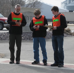 Alan Jensen and volunteers
in Riceville.
Alan Jensen and volunteers
in Riceville.
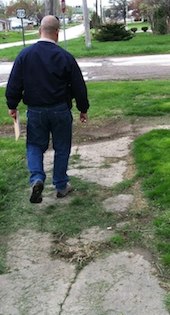
The volunteers hit the streets, collecting information about intersections, midblock sidewalks and other features that impede pedestrians and cyclists. They could photograph an intersection or sidewalk, pinpoint its location with the iPhones and send it to the data server.
They reported the existence and condition of sidewalks and lighting, overgrown vegetation, water pooling on sidewalks, frightening dogs, painted crosswalks, traffic control at intersections, heavy truck traffic and other characteristics.
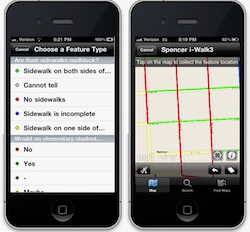 Customized iPhone app.
"We customized the app with our own questions and connected it with the GIS server so the data the volunteers collected was mapped online in real time," Seeger said.
"Geospatial data really helps in the design process," Seeger said. "And smart phones are going to be a valuable device for use for environmental research in which you want public input."
Some general findings
Although findings were specific to each community, Seeger identified a couple of generalities.
"Community size doesn't appear to determine whether or not kids walk to school," he said. "Our teacher tallies showed that it's all over the place. It really comes down to the culture of the community, the infrastructure and the school location."
And beyond considerations about how long it takes to walk to school or Iowa's quirky weather conditions, sidewalks are the biggest issue.
Residential areas built in recent years, Seeger said, were often developed without sidewalks.
"If you don't have sidewalks, you've already put the kids at a disadvantage because the only place for them to walk is in the street," he said. "Or in some older communities, the sidewalk infrastructure is crumbling and falling apart. Sidewalks require maintenance and are expensive to replace.
Finally, Seeger said communities need a coalition of school teachers and administrators, city officials, law enforcement and parents to make a project like this work.
"In order to promote walking or biking to and from school, it's essential to have the support of the community," he said.
"At the core I'm still looking at ways in which citizens can volunteer to share their knowledge about their neighborhoods and collect that knowledge spatially so decision makers can make better decisions about the future," Seeger said.
On Wednesday, Aug. 17, Seeger will present a paper, "Incorporating Volunteered Geographic Information into SRTS planning," at the National Safe Routes to School conference in Minneapolis.